
Direct Speech, Education and Science
International Internet Magazine. Baltic States news & analytics
Tuesday, 31.03.2026, 23:35
Addressing and management of cities, impact in economic development in Ivory Coast
 Print version
 |
|---|
Faced with the demographic explosion in the cities of
developing countries, mastering urban management has been made all the more
difficult since local authorities, new actors in this management in the context
of the ongoing decentralization movement, have often been unable to develop the
means to cope with urban growth.
Nowadays, Ivory Coast is facing a worrying situation for the
functioning of its urban services. Without a location system, simple question
remains - how to find yourself in an ever-growing city? How to quickly guide
ambulances, firefighters, security services? How identify or find an Ivorian
citizen in the event of a committing crime or in the event of an offense? How
to control local taxation?
This involves proceeding step by step, bringing local
managers step by step to master urban information: city mapping, coding of
lanes, census surveys, implementation of a simple computer system, development
of tools of applied management, in particular with a view to improving
resources by better identification of taxpayers.
Objective of the project:
- Effective reforms
in the identification of populations in Ivory Coast
- Modernize the
addressing with named and numbered streets in all regions in order to be able
to locate any individual living in Ivory Coast.
- Facilitate the
identification and localization of all citizens in all circumstances for the
proper functioning of economic activities
- Improve the return on taxation at the national level on
professional activities (VAT, local taxes) by setting up a database with a file
of companies.
In Ivory Coast, as in most African cities, the first
addressing systems appeared during the colonial era. After Independence, as
urbanization accelerated, the systems applied in the old city centers were not
extended to the new districts.
All cities have experienced very significant urban growth in
recent decades. This growth has often taken place in a disorderly context,
characterized, among other things, by the absence of a tracking system in the
city. And the method of addressing has remained the same since independence in
1960 until today. The will of the municipal authorities is, at present, to
improve services and urban management [1].
Abidjan is the economic capital of Ivory Coast and his population
continues to grow rapidly, as everywhere in Africa, to congregate around large
cities, Abidjan now approaches 5 million inhabitants.
In Ivory Coast, peoples of cities that have experienced and
/ or are experiencing strong and rapid urban growth often find themselves faced
with difficulties in locating and orienting themselves. The difficulties are also at the level of the
local authorities which are often unable to locate their citizens
geographically.
In Ivory Coast when you ask someone for his address, he will
answer you:
For example, my address: "22 BP 1964 Abidjan 21 Yopougon, Niangon"
22 BP 1962
means: the post office box
Abidjan 01 means:
The town
Yopougon means:
The commune
Niangon means:
District
An absence of address leads to a number of more or less
unfortunate consequences, such as the difficulty, or even the impossibility of
receiving parcel at home, receiving visitors, getting by taxi to a specific
address, receiving help quickly.
Addressing makes it possible to locate an area plot or
house, i.e. define its address from a system of cards and signs mentioning the
numbering or the names of streets and buildings.
This concept can be extended to urban networks and services.
In other words, you can not only give an address to a construction but also to
a specific "urban object" such as a street lamp, a taxi station.
The addressing and urban system of cities in Ivory Coast and France
Since the mid-eighties, the World Bank (IDA) and France
(French Cooperation - Ministry of Foreign Affairs) have contributed to the
financing of addressing operations in many African countries south of the Sahara.
In Côte d'Ivoire, the cities of Abidjan, Abengourou and San-Pedro
have benefited. However, the impact of this addressing is limited both within
populations and on the national economy.
However, a good addressing system and quality postal codes
are essential elements of a country's infrastructure and socio-economic
development. They serve as the basis for quality postal services and facilitate
commercial transactions and therefore the country's economic growth. In
addition, addressing the streets strengthens the efficiency of the Cadastre,
facilitates aid to people (location of intervention areas) and contributes to
participatory democracy by bringing citizens closer to the administration [2].
The main objective of addressing is to gain better knowledge
and location of each land entity. Communal taxation, almost nonexistent in
terms of effective return, was considered to be the first area of application
allowing each commune to assert a fair and transparent tax.
The carrying out of addressing operations and tax inquiries,
however, created a dynamic in the municipal services in charge of tax
collection: a dynamic more particularly visible for the Municipal tax levied on
small traders.
1.Tab. classification in Ivory Coast
|
Abidjan (economic capital) Density: 11 155
inhab./km 2 Number of
inhabitants: 4 707 404 inhab. (2014) Area: 42,200 ha =
422.00 km 2 percentage of the
urbanized area: 20% Streets called: 7% percentage of
doors addressed: 6% Yamoussoukro
(political capital) Density: 3,175
inhabitants / km 2 Number of
inhabitants: 362,000 inhab. (2014 ) Area: 11,400 ha =
114 km 2 percentage of the
urbanized area: 17% Streets called:
15% percentage of
doors addressed: 8% |
Codification of the
ways
The ways identifier is composed as follows:
For example, my address: "22 BP 1964 Abidjan 21 Yopougon, Niangon"
22 BP 1962 means: the post office box
Abidjan 01 means:
The town
Yopougon means:
The commune
Niangon means:
District
Door numbering
Until the early 1970s, addressing continued to be limited
essentially to the names of the city's main arteries, squares, and main
buildings. And the door numbering is not done, and this makes it difficult to
locate and identify Ivorian citizens. Streets signage almost don’t exist in the
Ivory Coast cities[3].
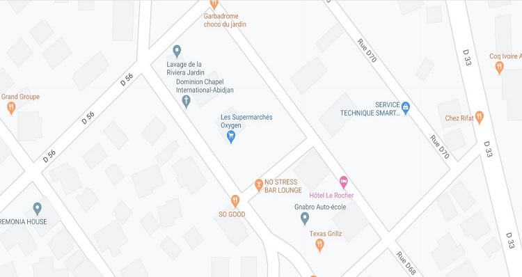
1.Addressing
plan in Abidjan
We
can see on the map that the majority of the streets do not have names.
Experience shows that it is practically impossible to assign names in a
systematic and rapid manner, since the name requires lengthy arbitrations by
the Municipality and the residents. The solution therefore consists in adopting
a channel numbering system, which will later and gradually be supplemented by
names [4].
2.Tab.
Classification in France
|
Paris (capital) Density: 20,000/km2 Number of inhabitants: 2.148 million inhab. (2020) Area: 105.4 km² percentage of the urbanized area: 98% Streets called: 98% percentage of doors addressed: 98% |
The
town planning in France includes the practice and conceptualization of urban
planning in France. This is distinguished at first by the establishment of
rules which are imposed in a regalian way on the right of private property
before constituting a specific planning right. But the rules of construction
and use of the land are not limited to this single right and must also take
into account the various related rights such as that of state property, the
environment, local authorities, heritage. But town planning goes far beyond its
legal framework. It is also based on a diagnosis of the strengths and
weaknesses of a territory, an inventory of assets, means and constraints. It is
also distinguished by its multi-scalar context: country, intercommunal, urban
area, department, region, state [5].
The
ways identifier is composed as follows:
For
example, my address:” Palace of Justice, 20, bd Saint Jean, BP
10325, 60000 BEAUVAIS”
20
bd Saint Jean means:
the door numbering and street named
BP
10325 means: the
post office box
60000
BEAUVAIS means:
District
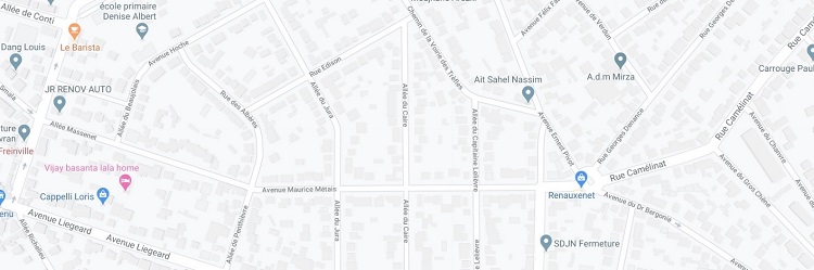
2. Addressing plan in Paris
The form of settlement on a territory is an essential
component of urban systems. Whatever the scale of observation at which one is
situated - department, region, country - there always appears to be a
regularity in the arrangement of the sizes of cities: cities tend to organize
themselves and spread over the territory according to of their dimension. The
theory of central places, resulting from the works of Christaller and Lösch,
constitutes an important spatial interpretation which accounts for the regularities
of the spacing and the inequality of the size of the cities according to the
level of their activities and their radiation [6].
The hierarchy formed by the distribution of the population
of agglomerations records all the variations that occur at the scale of cities.
Indeed, cities do not develop at the same rate, and their position in the urban
hierarchy fluctuates all the more since they are at the bottom of the
hierarchy. But despite the increase in the number of cities and their
population over time, one is struck by the remarkable stability of the shape of
the hierarchy of their size. Several interpretations have been given to justify
the existence and persistence of such a hierarchy: the result of a growth
process, the most probable state of equilibrium, or even, the result of a
dynamic of self-organization [7].
Result
The expected result is to facilitate travel and localization
in the cities of Ivory Coast, using inscriptions visible to all, identifying
the streets and the entrance to the constructions. For the identification of
the ways, we saw that the attribution of a name is a long and delicate
operation and that it is preferable first to adopt a numbering system allowing
to refer to known places or divisions Population.
Conclusions
The investigation between France and the Ivory Coast shows
that the position of France in this area is entirely within the European
average, whether it is the importance of urban sprawl or its evolution. We also
insist on the importance of taking into account, for the evaluation and
estimation of these trends, the situation of cities in city systems in Ivory
Coast. A recent article illustrates magnificently for France how these city
systems can be identified, at several geographic levels, from the interaction networks
that structure all kinds of relationships between cities.
References
1. Catherine
Farvacque-Vitkovic, Lucien Godin, Hugues Leroux, Florence Verdet et Roberto
Chavez, (2004) Adressage et gestion des villes (P.33)
2. Programme
national d’adressage , URL: http://www.cntig.net/index.php/recherche-developpement/programe-national-d-adressage
3. Pedro
De OLIVEIRA, (Novembre 2018) Les adresses et la
modernisation des pratiques urbaines au Bénin , CBP - RICOH Édition.
4. Dynamics
of development in Africa 2018 , URL : https://www.oecd.org/fr/developpement/dynamiques-du-developpement-en-afrique-2018-9789264302525-fr.htm
5. France
Guérin-Pace et Xavier Lesage,( 2001) Le système urbain français
,Éditions de l’EHESS.
6. Robert
Laugier. Février (2012 ) L’étalement urbain en France . France,
(P13).
7. Marianne
Guerois, Denise Pumain,( 2017), Des tendances de l'urbanisation en
France et en Europe, (P98-100).
- 30.12.2020 Business Education Plus предлагает анонсы бизнес-обучений в январе-феврале 2021 года
- 29.12.2020 18-19 января Наталия Сафонова проводит семинар "Управленческий учет во власти собственника"
- 28.12.2020 Новогодняя распродажа курсов Школы SMM Дамира Халилова
- 22.12.2020 Fin Tech компании могут переманить наиболее продвинутых клиентов латвийских банков
- 21.12.2020 22 декабря состоится онлайн-интенсив «Как перестать работать за своих сотрудников в 2021 году?»
- 18.12.2020 Влияние инструментов диджитал-маркетинга на латвийский рынок труда в сфере онлайн-образования в период пандемии
- 18.12.2020 19 декабря Марьяна Безруких выступит с лекцией "Развитие мозга и познавательной деятельности детей. Мифы и факты"
- 18.12.2020 Накануне 25-летия Балтийский курс/The Baltic Course уходит с рынка деловых СМИ
- 18.12.2020 Landsbergis: Lithuania to declare state of emergency if people fail to obey lockdown
- 18.12.2020 Crisis support for culture, sport, adults' hobby activities approved in Estonia (expands)


 «The Baltic Course» Is Sold and Stays in Business!